Peter Kabaila has undertaken a number of projects on Wiradjuri Country including producing a number of books that record historical events that have shaped the people who now populate this Country. Peter's association with Warangesda Aboriginal Mission and Station has been over many decades. Peter has collected and recorded many items from the site that have been previously held in a number of private collections. The maps of the area are based on historical maps in conjunction with personal recollections of various people who have had an association with the Mission site. This research has enabled him to provide a collection of maps that can be held for perpetuity and give a sense of place for those who are connected either through being a descendant of the original Aboriginal people who lived and worked on the Mission.
Peter has been very generous with his time and support of the various projects that have been undertaken such as the Heritage listing in 2010. For many of the descendants the listing was important to have some protection on the site but was disappointing as the site was listed as a ruin. The detailed maps produced by Peter were a substantial undertaking that record key points of the site. There are noted discrepancies which is indicative of these works. Overall though the maps and the archaeological works undertaken provide clear evidence of the importance of the area and why the impact of mission life reverberates to this day. Peter's work captures the overwhelming changes to previous cultural safety that was enjoyed by Aboriginal people before invasion and the systematic genocide of the Wiradjuri people and other nations in neighbouring countries.
It is important that these maps and the archaeological works undertaken by Peter are used in conjunction with other historical information that is available in regards to the Mission Site. Given the era there are many factual accounts available to use in conjunction with these maps. It was a sign of the times how and why data was collected on the Aboriginal people who were ruled by policies that were subjective of the invaders.
Click to see the plan of the 1880 layout of Warangesda (by Peter Kabaila).
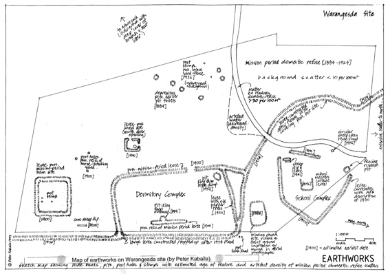
Click to see the Map of Earthworks on the Warangesda site (by Peter Kabaila).